History Optional
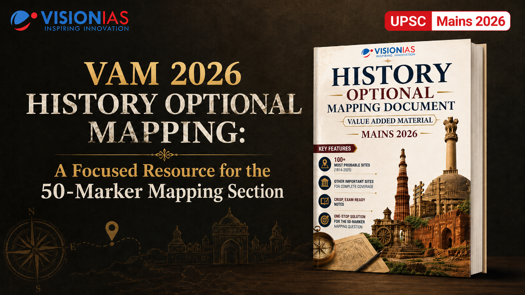
VisionIAS VAM 2026 History Optional Mapping: A Focused Resource for the 50-Marker Mapping Section in UPSC Mains


For aspirants with History Optional, the Mapping Section in Paper-I is one of the most rewarding areas of preparation. It is precise, scoring, and appears consistently in the examination. Yet, it is also a section where many aspirants lose marks because of scattered preparation, weak location recall, and vague notes.
Unlike a conventional theory question, the map section demands a combination of location accuracy, historical identification, concise explanation, and exam-oriented recall. Aspirants must not only identify the site correctly on the map, but also write a crisp note that directly matches the locational hint given in the question.
This is where VisionIAS History Optional Mapping Document – Value Added Material Mains 2026 becomes a highly useful resource. It has been designed as a focused, revision-friendly and exam-oriented document for the Mapping Section of History Optional Paper-I.
[Download History Optional Mapping VAM 2026 PDF]
Why the Mapping Section Matters in History Optional
The Mapping Section in History Optional Paper-I carries 50 marks. Since it appears every year, it provides aspirants with a clear opportunity to improve their optional score through systematic preparation.
A well-prepared candidate can gain an additional edge because the section rewards accuracy, brevity and recall. However, the challenge lies in the vastness of possible sites. UPSC may ask conventional locations such as Harappan, Buddhist, port, temple or cave sites, but recent trends also show growing attention towards relatively lesser-known archaeological and cultural locations.
Therefore, mapping preparation should not be random. It should be based on:
- Previous year trends
- High-probability sites
- Accurate location recall
- Category-wise organisation
- Crisp 30–40 word notes
- Site-specific identifying features
- Map-based visual revision
- Regular practice under time limits
Why VisionIAS History Optional Mapping VAM 2026 is Useful
1. Trend-Based Selection of Sites
The document is built on an analysis of UPSC Mapping questions from 2014 to 2025. This makes the preparation more targeted and relevant. Instead of attempting to cover every possible location without direction, aspirants can focus on sites that have stronger examination relevance.
The document includes both high-frequency sites and relatively lesser-known locations that may become important based on recent examination patterns.
2. Expanded Coverage for Mains 2026
The revised edition expands coverage by including additional locations beyond the conventionally important ones. This is especially useful because UPSC has shown a tendency to test lesser-known but historically significant sites.
The document covers a wide range of categories, including:
- Paleolithic and Mesolithic sites
- Neolithic sites
- Chalcolithic sites
- Harappan sites
- Megalithic sites
- Ancient ports
- Ancient cities
- Ancient educational centres
- Rock-cut sites and caves
- Ancient temple sites
- Painted Grey Ware sites
- Buddhist sites
- Miscellaneous important sites
3. Focus on Concise, Exam-Ready Notes
In the exam, aspirants are expected to write short notes within a limited word range. Long descriptions are neither possible nor useful. The document therefore provides crisp, focused and revision-friendly descriptions for each site.
For every site, the content usually includes:
- Location
- Key findings
- Historical or cultural significance
- Unique identifying feature
- Exam relevance
This structure helps aspirants remember what exactly to write when a site appears in the map question.
4. Map-Oriented Learning
Mapping is not just about reading site names. It requires visual memory. Aspirants must be able to locate the site accurately on a political map and connect the site with the right historical context.
The VAM includes map-based presentation of site clusters, helping aspirants develop stronger spatial recall.
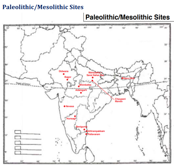
For example, prehistoric sites are organised through maps showing locations such as Adamgarh, Bagor, Bhimbetka, Didwana, Hunsagi, Attirampakkam, Pallavaram, Sarai Nahar Rai and others.
What Makes This Mapping Document Exam-Oriented?
1. It Helps Aspirants Align Notes with the Locational Hint
One common mistake in the map section is writing a generic note that does not match the hint given in the question.
For example, if a question identifies a site as an ancient temple site, the note must focus on its religious, architectural or cultural significance. If the same location is identified as an ancient capital city, the answer should highlight its political or administrative relevance.
This document trains aspirants to think in terms of the site’s most relevant identifying feature.
2. It Encourages Time-Bound Writing
The map section should not consume excessive time. Aspirants are advised to allocate around 25–30 minutes for this section. This means every note has to be short, relevant and direct.
The VAM’s crisp note format supports this requirement. Instead of writing bulky descriptions, aspirants can revise key points and reproduce them in 30–40 words.
3. It Builds Category-Wise Clarity
History mapping becomes easier when sites are grouped thematically. For example, Harappan sites should be revised together, Buddhist sites together, port sites together, and rock-cut cave sites together.
This helps aspirants identify patterns and recall sites faster during the examination.
For example:
- Prehistoric sites help in questions related to early human habitation, lithic tools, rock art and burial practices.
- Harappan sites help in questions related to urban planning, trade, craft production, drainage, seals and regional variation.
- Megalithic sites help in questions related to burial practices, iron use and early historic transition.
- Ancient ports help in questions related to maritime trade and cultural exchange.
- Buddhist sites help in questions related to religious centres, stupas, monasteries and pilgrimage networks.
Sample: How the VAM Helps in Writing a Map Note
Let us take a sample site from the prehistoric category.
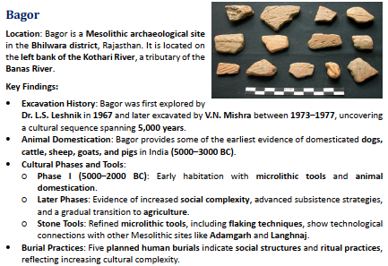
Example: Bagor
A generic answer may only write that Bagor is a Mesolithic site in Rajasthan. However, a better answer should include its location, cultural phase and distinctive findings.
A concise exam-ready note may include:
Bagor, located in Bhilwara district of Rajasthan on the Kothari River, is an important Mesolithic site. It is known for microlithic tools, early evidence of animal domestication, planned human burials and cultural transition towards settled life.
This note is brief, location-specific and historically meaningful.
Key Areas Covered in VisionIAS History Optional Mapping VAM 2026
1. Paleolithic and Mesolithic Sites
This section includes important sites such as Adamgarh, Attirampakkam, Bagor, Bhimbetka, Chaupani Mando, Didwana, Garo Hills, Hunsagi, Mahadaha, Nevasa, Pallavaram, Renigunta and Sarai Nahar Rai.
These sites are important for understanding early human habitation, tool technology, rock art, microliths, burial practices, domestication and adaptation to different ecological regions.
2. Other Paleolithic and Mesolithic Sites
The document also includes lesser-known but examination-relevant sites such as Baghor I, Damdama, Giak, Isampur, Khangkhui Caves, Khowai Valley, Langhnaj, Pahalgam, Paisra and Patne.
This is useful because UPSC may ask relatively less conventional sites to test deeper preparation.
3. Neolithic Sites
The Neolithic section includes sites such as Ahar, Barudih, Burzahom, Chirandh, Daojali Hading, Hallur, Koldihwa, Mehrgarh, Navdatoli, Paiyampalli, Piklihal, Tekkalkota and Lakhudiyar.
These sites are important for themes such as early agriculture, domestication, polished stone tools, settled life, regional variation and transition from food gathering to food production.
4. Chalcolithic Sites
The Chalcolithic section covers sites such as Ganeshwar, Jorwe, Kayatha and Pandu Rajar Dhibi, along with other important sites like Balathal, Gilund, Eran, Inamgaon, Mahisdal, Semthan and Senuwar.
This section helps aspirants revise copper use, village settlements, pottery traditions, agricultural expansion and regional cultures.
5. Harappan Sites
The Harappan section includes sites such as Alamgirpur, Amri, Balu, Bhagwanpura, Daimabad, Dholavira, Desalpur, Kalibangan, Kot Diji, Lothal, Manda, Mundigak, Padri, Rakhigarhi, Rojdi, Ropar, Shortugai, Sutkagendor and Surkotada.
It also includes other Harappan sites such as Allahdino, Balakot, Chanhudaro, Ganweriwala, Harappa, Mohenjo-Daro, Rehman Dheri and Farmana.
This section is useful for mapping the spread, regional diversity and economic networks of the Harappan civilisation.
6. Megalithic Sites
The document covers major megalithic sites such as Adichanallur, Amravati, Brahmagiri, Chandravalli, Hallur, Hire Benakal, Junapani, Kodumanal, Maski, Porkalam, Sanur and Sisupalgarh.
It also covers other megalithic sites such as Nartiang, Willong Khullen, Vangchhia, Cheramangad, Sittannavasal, Machad, Halingali and the Vidarbha Megalithic Cluster.
This section helps aspirants prepare for questions on burial traditions, iron use, regional cultures and early historic transitions.
7. Important Ancient Ports
Ancient ports are important for understanding trade, maritime networks and cultural exchange. The document includes sites such as Arikamedu, Bharukachchha, Muziris, Kaveripattinam, Sopara and Tamralipti.
It also includes other port sites like Barbaricum, Ghantasala, Kalliana, Korkai and Tyndis.
These sites are useful for questions on Indo-Roman trade, Indian Ocean networks, coastal commerce and early historic urbanisation.
8. Important Ancient Cities
The document includes ancient cities such as Badami, Bagram, Gangaikondacholapuram, Halebidu, Kannauj, Pataliputra, Paithan, Pragjyotishpur, Pushkalavati, Rajgir, Thanesar, Vaishali, Vidisha and Vengi.
Other ancient cities include Kanchipuram, Aihole, Kaushambi, Mathura, Pattadakal, Sringaverapura, Ujjain, Tosali, Kandahar, Purushapura and Sakala.
This section helps aspirants prepare for sites linked with political centres, cultural regions, dynastic history and urban development.
9. Ancient Educational Sites
The document includes major educational centres such as Nalanda, Vikramshila and Vallabhi.
These sites are important for questions on ancient learning traditions, Buddhist education, monastic universities and intellectual networks.
10. Rock-Cut Sites and Caves
This section covers sites such as Ajanta, Bagh Caves, Elephanta, Ellora, Jogimara Caves, Nashik Caves, Udayagiri-Khandagiri and Undavalli Caves.
It also includes Barabar Caves, Bhaja Caves, Kanheri Caves, Karla Caves and Udayagiri Caves at Vidisha.
These sites are useful for questions on rock-cut architecture, religious patronage, Buddhist caves, Jain caves, Hindu iconography and artistic evolution.
11. Ancient Temple Sites
The temple section includes Bhubaneswar, Bhitargaon, Da Parbatia, Dhakeshwari, Martand Sun Temple, Masrur Rock-Cut Temple Complex, Nagari, Sirpur and Thanjavur.
Other temple sites include Dashavatara Temple, Mahabalipuram, Tigawa and Nachna Kuthara.
This section helps in revising temple architecture, regional styles, religious centres and artistic developments.
12. Painted Grey Ware and Buddhist Sites
The Painted Grey Ware section includes sites such as Ahichhatra, Atranjikhera, Hastinapur and Lal Qila.
The Buddhist sites section includes Amaravati, Bamiyan, Nagarjunakonda, Sanghol, Sravasti, Vadnagar, Bodh Gaya, Kushinagar, Piprahwa, Sanchi, Sarnath, Phanigiri and Kanganhalli.
These sites are important for questions on early historic archaeology, religious networks, stupas, monasteries and Buddhist art.
13. Miscellaneous Important Sites
The document also includes sites such as Ashmaka, Chandraketugarh, Dhauli, Dwarka, Hathnora, Keezhadi, Madurai, Mahasthangarh and Taxila.
Other important sites include Bairat, Bhita, Bhitari, Girnar, Kalsi, Lauriya Nandangarh, Mansehra and Shahbazgarhi.
This section is especially useful for revising sites that may not fit neatly into one category but have strong examination relevance.
How to Use This Mapping Document Effectively
Step 1: Start with Category-Wise Revision
Do not begin with random site names. Revise sites category-wise: prehistoric, Neolithic, Harappan, Megalithic, ports, cities, Buddhist sites, temples and caves.
Step 2: Mark High-Probability Sites
Prioritise sites that have appeared in previous years or are strongly linked with recurring UPSC themes. Also revise lesser-known sites included in the document because UPSC has shown interest in such locations.
Step 3: Practise Map Plotting
Reading site descriptions is not enough. Plot each site repeatedly on a blank political map of India and surrounding regions. This will strengthen visual memory.
Step 4: Prepare 30–40 Word Notes
For each site, prepare a short note using this format:
- Location
- Period / category
- Key findings
- Historical significance
For example:
Dholavira: Located in Kachchh, Gujarat, Dholavira is a major Harappan site known for its planned city layout, water conservation system, inscriptions and evidence of urban sophistication in a semi-arid environment.
Step 5: Revise Locational Hints
For some sites, the same location may be relevant under more than one category. Prepare the answer according to the hint given in the question.
Step 6: Use Visual Revision
Use the maps in the document for quick revision. Create mental clusters such as:
- Narmada Valley sites
- Ganga Valley Mesolithic sites
- South Indian Paleolithic sites
- Gujarat Harappan sites
- Buddhist sites of the Gangetic region
- Ancient ports on western and eastern coasts
Step 7: Practise Under Time Limit
During practice, keep the map section within 25–30 minutes. This ensures that the rest of Paper-I is not affected.
Last-Mile Benefits of VisionIAS History Optional Mapping VAM 2026
During the final phase before Mains, aspirants need a resource that is compact, structured and high-yield. This document helps by providing:
- 100+ most probable sites
- Additional important sites for wider coverage
- Trend-based selection from 2014–2025
- Crisp site-wise notes
- Map-based location practice
- Category-wise organisation
- Exam-day tips
- 30–40 word note orientation
- Coverage of high-frequency and lesser-known sites
- Better preparation for the 50-marker Mapping Section
[Download History Optional Mapping VAM 2026 PDF]
Final Word
The Mapping Section in History Optional can become a scoring component if prepared with accuracy, discipline and regular practice. It does not require lengthy answers, but it does require clarity of location, historical relevance and concise expression.
VisionIAS History Optional Mapping Document VAM 2026 is designed to support this exact need. It helps aspirants revise important sites, understand recurring trends, practise map-based recall and write exam-ready notes.
Use it not merely as a list of locations, but as a structured revision resource. Mark the maps, revise the notes, practise blank-map plotting, and prepare crisp 30–40 word answers.
When location accuracy meets historical understanding and concise writing, the Mapping Section becomes a strong scoring opportunity.
Let VisionIAS History Optional Mapping VAM 2026 be your focused companion for the 50-marker Mapping Section in History Optional Paper-I.
FAQs on VisionIAS History Optional Mapping VAM 2026
1. What is VisionIAS History Optional Mapping VAM 2026?
VisionIAS History Optional Mapping VAM 2026 is a focused resource for the Mapping Section of History Optional Paper-I. It includes important archaeological, cultural and historical sites with map-based location support and concise notes.
2. Why is mapping important in History Optional?
The Mapping Section carries 50 marks and appears consistently in Paper-I. With systematic preparation, aspirants can improve their optional score through accurate map plotting and short, relevant notes.
3. What kind of sites are covered in this document?
The document covers prehistoric, Neolithic, Chalcolithic, Harappan, megalithic, port, city, educational, cave, temple, Painted Grey Ware, Buddhist and miscellaneous important sites.
4. How should aspirants write notes in the map section?
Each note should be around 30–40 words and should directly match the locational hint. It should include the site’s location, period or category, key finding and historical significance.
5. What is the best way to use this VAM?
Revise sites category-wise, practise plotting on blank maps, prepare crisp notes, focus on high-probability and lesser-known sites, and practise the full map section within 25–30 minutes.