The Darjeeling landslides expose how fragile infrastructure and unsustainable development have deepened disaster risks, necessitating wide-ranging NDRF rescue operations.
On the night of October 4, 2025, torrential rains triggered devastating landslides across multiple locations in the Darjeeling hills. This disaster resulted in numerous casualties and extensive infrastructure damage.
Compounding the crisis in North Bengal, a technical malfunction in the gates of Bhutan's Tala Hydropower Dam resulted in the Wangchu river overflowing. The Druk Green Power Corporation (DGPC) reported the malfunction to Bhutan's National Centre for Hydrology and Meteorology (NCHM), which formally alerted the West Bengal government to prepare for potential downstream impacts.
Understanding Causes of Landslides in Himalayas
The causes of landslides in the Darjeeling Himalayas involve geological vulnerability, climatic factors, and human intervention.
Geological Factors
The Eastern Himalayan region contains unstable geological structures. Formed by the collision of the Indian and Eurasian plates, the Himalayas are young fold mountains characterized by faults and fractured rocks, making them inherently unstable. The mountains consist of soft rocks such as schists, phyllite, and gneiss that possess low shear strength and destabilize when saturated with water.
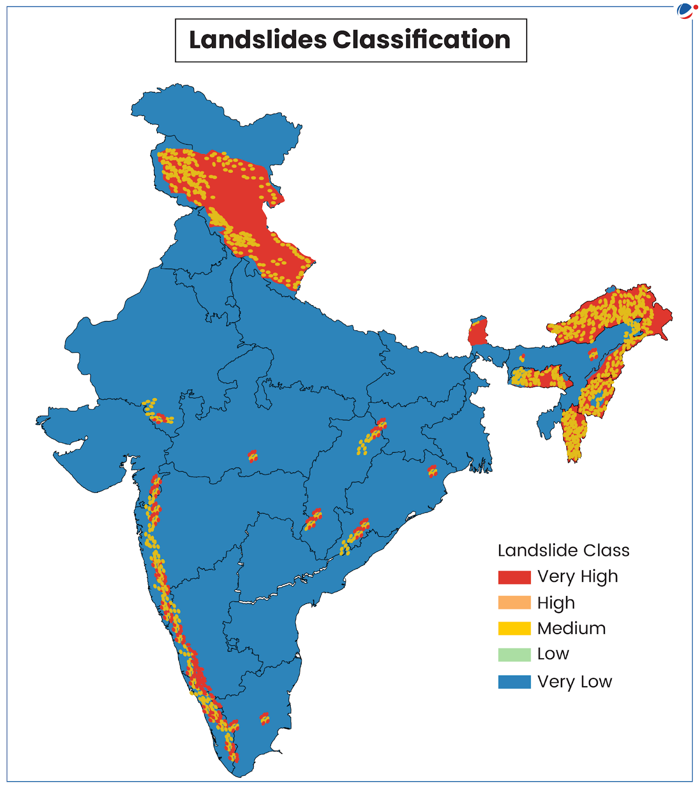
Additionally, the region’s steep slopes and frequent seismic activity further aggravate this fragility, contributing to recurring slope failures. According to ISRO's 2023 Landslide Atlas of India, 12.6% of India's land area is prone to landslide hazards, with more than three-fourths of this vulnerable area located in the Himalayan region alone.
Heavy Rainfall as Trigger
Heavy rainfall is the primary triggering factor for slope failures. Monsoon rainfall, along with cloudbursts and snow melt, saturates soil, increasing pore water pressure within soil and rock masses, reducing stability and causing slopes to shift from stable to unstable conditions within hours. The Darjeeling landslide 2025 demonstrated this mechanism.
Researchers have established Intensity-Duration thresholds for landslide initiation in this region. The concentrated downpour of over 300 mm in 12 hours exceeded these thresholds, triggering widespread failures.
In addition, the rising population and changing river courses in the region have intensified pressure on fragile hill ecosystems, altering hydrological patterns and accelerating erosion. Climate change has further increased the occurrence of extreme weather events, making such disasters more frequent and severe.
Deforestation and Development Pressures
Human-induced destabilization represents a preventable factor among the causes of landslides. Deforestation removes root networks that provide natural soil reinforcement. When forests are cleared for construction, exposed soil becomes vulnerable to erosion and collapse during heavy rains.
Tourism growth in Darjeeling has accelerated construction from homestays to hotels often built by cutting into unstable hillsides. This pattern of unsustainable and unregulated development has magnified ecological risks.
The conversion of agricultural and forest land into built-up areas, coupled with expanding road networks, has disrupted surface runoff and sediment balance. Mining, land-use changes from urbanization, infrastructure projects, and encroachments further disrupt natural drainage systems.
Historical Context of Landslide Events in Darjeeling
The Darjeeling hills have experienced recurring disasters throughout recorded history. Major landslides and floods occurred in 1899, 1934, 1950, 1968, 1975, 1980, 1991, 2011, and 2015. The 1968 floods provide an important reference point. Continuous rainfall lasted four days. It reached approximately 1,000 mm over 52 hours. This triggered numerous landslides with casualties exceeding one thousand.
A pattern has emerged with failures occurring in October during 1968, 2015, and 2025, suggesting possible shifts in regional climatic conditions. There is an increased occurrence of high-intensity rainfall events during the post-monsoon period. The resulting landslides outside the traditional monsoon season, potentially indicate an extension of the period when slopes are vulnerable to hydrological stress.
Disaster management in Darjeeling faces structural challenges from "dual administration" between the West Bengal Government and the Gorkhaland Territorial Administration (GTA). This arrangement creates coordination difficulties, impeding unified disaster planning and response.
A governance gap exists at the grassroots level. Unlike neighboring Sikkim, the GTA region lacks defined roles for local government bodies in landslide risk management. Since disaster risk reduction requires localized implementation, this institutional gap reduces the effectiveness of central and state mandates.
Reform measures should establish unified disaster management frameworks between West Bengal and the GTA, while empowering local governance bodies with specific mandates for grassroots disaster risk reduction activities.
Policy Frameworks for Rehabilitation
Post-disaster recovery must adopt a rights-based approach, moving beyond administrative tasks to ensure dignity for displaced persons and protection for vulnerable groups. Policy implementation should align with the National Rehabilitation and Resettlement Policy, 2007 (NRRP-2007), including mandatory Social Impact Assessments for large projects.
Reconstruction policy must address unauthorized settlements, defining relocation mechanisms for residents in hazardous zones while ensuring humanitarian standards. The policy framework should enforce hazard-safe design standards for all construction, including private housing and government schemes.
Long-Term Mitigation Strategies
Transitioning from reactive response to proactive resilience requires changes in governance, planning, and engineering approaches.
Geospatial Planning and Land-Use Controls
Landslide Susceptibility Zonation (LSZ) maps should serve as the foundation for regional planning. These maps, categorizing zones by stability levels, must be integrated into land-use decisions through legal mandates. Construction in areas classified as high and very high susceptibility should be prohibited.
Structural and Bioengineering Solutions
Important roads like NH-10 need better protection from landslides. One solution is to build tunnels or elevated roads (called viaducts) that bypass dangerous areas and unstable slopes altogether.
Engineers can also use special drainage systems. These systems remove water from inside hillsides through horizontal pipes. When water is drained out, it reduces pressure in the soil. This makes slopes more stable and less likely to collapse.
Local plants and trees can help hold soil in place naturally. This approach is called bioengineering. It uses living materials instead of just concrete and steel. Some effective techniques include:
- Brush layering: Planting branches and stems in layers along the slope
- Live crib walls: Building wooden or bamboo frames filled with soil and living plants
- Vegetated gabions: Wire mesh boxes filled with rocks and planted with vegetation
These methods provide two benefits. First, they strengthen slopes and prevent landslides. Second, they help restore the natural environment. Local people can also continue farming and other activities on these hillsides.

Early Warning System Enhancement
Landslide Early Warning Systems (LEWS) exist but face operational constraints due to infrastructure deficits. Dedicated Doppler Weather Radars in the mountainous Darjeeling-Sikkim region are necessary to provide localized rainfall data for warnings.
Conclusion
The Darjeeling landslide resulted from a combination of geological vulnerability, extreme rainfall, and development patterns in hazard-prone areas. Geological instability and heavy rainfall are inherent characteristics of the Eastern Himalayan region. However, human activities that increase landslide risk including deforestation, construction in vulnerable zones, and alterations to natural drainage can be managed through appropriate policies and planning.
Effective mitigation strategies include afforestation programs to restore vegetation cover, enforcement of land-use regulations based on scientific hazard mapping, infrastructure design that incorporates resilience principles, and improved early warning systems with adequate meteorological monitoring.
Institutional reforms to address coordination challenges between administrative bodies would support more effective disaster management approaches. The scientific understanding of landslide causes in Darjeeling provides a foundation for evidence-based mitigation measures. Implementation depends on administrative coordination, resource allocation, and sustained commitment to risk reduction frameworks.

Master Digital Age Governance & Technology Trends with VisionIAS Comprehensive Current Affairs →
Darjeeling Landslides FAQs
1. What is the primary cause of landslides in Darjeeling?
Heavy rainfall triggering slope failures.
2. What rainfall amount triggered Darjeeling landslide 2025?
Ans. Over 300 mm in 12 hours.
3. What are the main human causes of landslides in Darjeeling?
Ans. Deforestation and unregulated construction development.
4. How much of India's land area is vulnerable to landslides?
Ans. 12.6% of India's land area is prone to landslide hazards, with over three-fourths located in the Himalayan region.
5. What role does climate change play in Himalayan landslides?
Ans. Climate change has increased the occurrence of extreme weather events, making landslides more frequent and severe in the region.