Current Affairs
NISAR: Revolutionising Earth Observation Through India-US Space Partnership
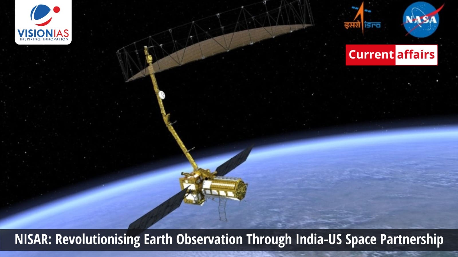


ISRO and NASA jointly developed NISAR, a global microwave imaging mission, to study Earth’s surface changes, including earthquakes, volcanoes, ecosystems, and floods.
The NASA-ISRO Synthetic Aperture Radar (NISAR) launched from GSLV-F16 is a collaboration between the Indian Space Research Organisation (ISRO) and the National Aeronautics and Space Administration (NASA).
This first-of-its-kind joint endeavor is an L and S-band global microwave imaging mission, designed to acquire fully polarimetric and interferometric data. More than just a satellite, NISAR exemplifies the potential of the U.S.-India cooperation in leveraging space technology to address global challenges.
Understanding NISAR
NISAR is an Earth observation satellite built on ISRO’s I-3K structure. It carries L and S-band Synthetic Aperture Radars (SAR). Unlike optical satellites that are limited by weather conditions and daylight, NISAR operates with consistency, functioning through clouds, smoke, and vegetation, both day and night.
The satellite’s dual-radar system works like having two types of eyes looking at Earth. The L-band radar acts like an X-ray machine, which can see through forest canopies and penetrate soil to detect underground changes. This makes it suitable for tracking how forests are growing or shrinking, monitoring ice movement within glaciers, and detecting shifts in the ground that might signal an upcoming earthquake.
The S-band radar focuses on surface details like a camera. It works well for monitoring crop health, detecting changes in snow cover, and measuring soil moisture levels. Together, these two systems provide a complete picture—L-band tells us what’s happening below the surface, while S-band shows us surface conditions.
Technical Excellence and Innovation
The NISAR also incorporates several groundbreaking technologies that set new standards for Earth observation missions. It’s a massive 12-meter deployable mesh antenna, one of the largest ever used for Earth observation. This enables wide imaging swaths of over 240 kilometres while maintaining high resolution.
The innovative SweepSAR architecture, implemented for the first time in space, allows the satellite to cover vast areas without compromising image quality. NISAR will scan nearly all of Earth’s land and ice surfaces every 12 days, generating approximately 80 terabytes of data daily, more than any previous remote-sensing satellite.
The mission’s technical complexity required unprecedented coordination between teams working across continents. ISRO developed the S-band radar system, data handling, downlink, spacecraft, and launch system. NASA provided the L-band radar system, downlink, Solid-State Recorder, GPS receiver, and the 9m boom with its 12m reflector.
ISRO handles satellite commanding and operations, while NASA provides orbit maneuver and radar operations plans. Both ISRO and NASA ground stations will download acquired images, which will then be processed and shared with users. This successful integration of components developed independently demonstrates remarkable engineering coordination and mutual trust between the two agencies.
Transformative Scientific Applications
NISAR’s capabilities extend across multiple critical domains that directly impact global challenges:
Climate and Environmental Monitoring: Think of NISAR as Earth’s health monitor. It watches over ice sheets and glaciers, like checking Earth’s temperature through its frozen regions. When glaciers melt faster than usual, NISAR detects it, helping scientists understand how sea levels might rise.
Disaster Management and Risk Assessment: NISAR works like a sensitive seismograph in space, but much more powerful. It can detect ground movements as small as a few millimetres. This sensitivity means it can spot the early signs of earthquakes, landslides, or volcanic activity before they become dangerous.
Agricultural and Food Security: For farmers, NISAR is like having a super-powered agricultural advisor in space. The satellite can tell farmers exactly how much water their crops need by measuring soil moisture levels across vast areas.
Ecosystem and Biodiversity Conservation: NISAR monitors forests and wetlands like an environmental accountant, keeping track of Earth’s green wealth. It can measure how much carbon forests are storing and whether they’re gaining or losing biomass. When illegal logging occurs or natural disasters damage forests, NISAR detects these changes within days.
Global Impact and Open Data Policy
The partnership between NASA and ISRO represents a shift in space diplomacy. This collaboration builds upon decades of cooperation, including India’s Chandrayaan-1 lunar mission that carried NASA’s Moon Mineralogy Mapper instrument. However, NISAR marks the first instance where these two space agencies have developed a complete satellite system from conception to launch.
NISAR launched onboard GSLV-F16 launch vehicle on July 30, 2025 from ISRO’s Satish Dhawan Space Centre (SDSC), also referred to as Sriharikota High Altitude Range (SHAR), located in Sriharikota on the southeast coast of the Indian peninsula.
This also demonstrates India’s growing capabilities in the global space arena. The mission reflects India’s vision of ‘Vishwa Bandhu’, a global partner contributing to humanity’s collective good. This partnership between India and the US space agencies showcases how collaborative efforts can achieve outcomes.
One of NISAR’s most significant aspects is its commitment to global scientific equity through open data access. All mission data will be freely available worldwide within one to two days of collection, with near real-time access during emergencies. This democratisation of high-quality Earth observation data particularly benefits developing countries that lack indigenous satellite capabilities.
The mission’s open data policy transforms space-derived information into a global public good, supporting international climate research, disaster response, and environmental monitoring efforts. This approach reinforces the principle that addressing global challenges requires shared access to critical information and collaborative scientific efforts.
Strategic Implications for India
For India, the NISAR satellite mission represents multiple strategic benefits. It positions the country as a global leader in advanced Earth observation technology while strengthening the India-US strategic partnership. The mission aligns with India’s national priorities, including climate commitments under the Paris Agreement, disaster risk reduction, and sustainable development goals.
ISRO’s prominent role in the mission, from providing the spacecraft bus and S-band radar to conducting the launch, demonstrates India’s mature space capabilities. The collaboration creates valuable technical knowledge and experience that will benefit future space missions and strengthen India’s position in the global space economy.
Future Prospects and Long-term Vision
The success of NISAR establishes a blueprint for future international space collaborations. The mission’s innovative co-development model, where both agencies contribute equivalent expertise and resources. This can inspire similar partnerships addressing other global challenges.
The continuous stream of high-resolution data from NISAR will likely accelerate the integration of artificial intelligence and machine learning in Earth system modelling. This technological evolution promises more accurate climate predictions, enhanced disaster preparedness, and improved environmental management strategies.

Conclusion
The NISAR represents more than a technological achievement as it embodies a vision of international cooperation addressing shared planetary challenges. Through the NASA-ISRO partnership, this Earth observation satellite will provide unprecedented insights into Earth’s dynamic processes, supporting climate science, disaster management, and sustainable development efforts worldwide.
The mission stands ready to revolutionise our understanding of Earth’s changing systems. By combining cutting-edge technology with open data access and international collaboration, NISAR exemplifies how space exploration can serve humanity’s collective interests while strengthening strategic partnerships between nations.
The mission’s success will undoubtedly inspire future collaborative efforts, demonstrating that the most pressing global challenges require shared expertise, resources, and commitment to the common good.
Master Digital Age Governance & Technology Trends with VisionIAS Comprehensive Current Affairs →
NISAR Satellite FAQs
1. What does NISAR stand for?
Answer: NASA-ISRO Synthetic Aperture Radar.
2. Which countries built NISAR?
Answer: India and the United States.
3. What can NISAR detect?
Answer: Earthquakes, floods, crop health, and ice movement.
4. How often does NISAR scan Earth?
Answer: Every 12 days.
5. Where will NISAR launch from?
Answer: Satish Dhawan Space Centre, India.